› Forums › Hiding and Hunting › Benchmarking › Disk not in NGS database…
- This topic has 14 replies, 3 voices, and was last updated 15 years, 6 months ago by
glorkar.
-
AuthorPosts
-
07/11/2010 at 11:39 pm #1730463
I stumbled on a USGS Benchmark disk from 1952. The station name looks like a couple of letters/numbers are worn. I can read “TT F11,” but it looks like there might be something else in front of the “F11” It even had a witness post right next to it. I tried everything and can’t locate it on the NGS site (or Holograph’s for that matter.)
I found it near:
N 43 43.649 W 89 00.362
I can get anyone a bigger picture if they like.
 07/12/2010 at 3:46 pm #1933053
We’ve found more benchmarks that were unlisted, than we have found that were listed.
07/12/2010 at 4:04 pm #1933054Glorkar – can you tell me what county you found it in? I will see if I have it listed in my database.
07/12/2010 at 6:29 pm #1933055TDSG:
I’ve found a few WISDOT marks that aren’t in the NGS database, but this is the first USGS one I’ve found that isn’t. 2/3rds of the marks I’ve found aren’t on GC.Astro-D:
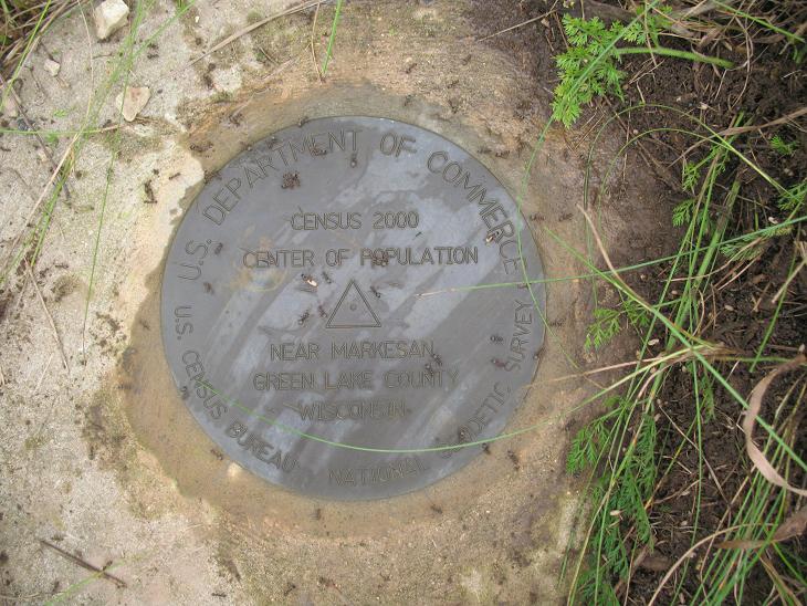
I found it in Green Lake County, near Markesan (maybe a quarter mile West of the Center of Population mark.)07/12/2010 at 6:58 pm #1933056I looked in my records and I have nothing. I don’t even have a USGS mark recorded for Green Lake county. I even scanned Green county just to see if an error was made and I didn’t see anything there either.
My records have all the WIDOTs that were included when I prinited it out a year or two ago. Wonder why this mark is missing?
On another note, did you get the center of population mark? Got a pix to share?
07/12/2010 at 8:16 pm #1933057I sure did get the CoP mark. Even ran into a couple of other cachers that were grabbing the info off of it for the associated cache. Ended up being MuddyBottoms and OldlyWeds.
I got some friends when I was cleaning off the mark too. I had pulled some weeds and brushed a clump of dirt away….only it wasn’t a clump of dirt, it was an ant hill! In less than a minute there were at least 50-100 ants all over the marker. you can see a bunch of them in the picture. Usually I’ll dump some water on the disk, then wipe it dry. No wiping on this one 🙂
 07/12/2010 at 8:25 pm #1933058
Just got this posted to my question in the GC forum:
The U.S. Geological Survey (USGS), an agency in the Dept. of the Interior has the responsibility for producing our national topographic maps. They completed the monumental task of complete national mapping of the 1:24,000 scale map series (about 55,000 maps) in the early 1990’s. USGS would often set survey monuments to help “control” the map. Maps are produced from aeronautical photos mosaiced together. In order to provide accurate location, orientation, scale and elevation to a flat map of a curved surface, it is required to have numerous points that can be identified on the photographs for which the coordinates/elevations are well known. The marks set by USGS were a vital part of this operation. In the days when mapping surveys were conducted primarily by line-of-site methods, these marks helped save money by helping to ensure a network that cartographers could rely on for mapping update procedures. With the rapid developments in surveying and mapping technology, especially GPS, USGS sees little need to setting new marks or maintaining the old networks. Unfortunately the data for tens of thousands of these marks set by USGS were never submitted to NGS for inclusion in the National Spatial Reference System. Due to major reductions in staff and the changing nature of mapping requirements, it is highly unlikely that USGS will ever automate these data
07/12/2010 at 8:38 pm #1933059I ws over there today and saw the replies. I think we may have to tagteam for a stone one. Maybe several sets of eyes and brains might work out well.
Nice shot of the CoP mark! I hope to grab that one someday myself! But first I need a new GPSr and a laptop!
07/12/2010 at 8:44 pm #1933060@AstroD-Team wrote:
But first I need a new GPSr and a laptop!
Pssh! I used Bing maps and my eye balls. You can’t miss it, what with the big white info sign and the two bright orange witness posts! I would post a pic of the sign, but it would be a give away for the cache.
I still have to get up by you to grab the GEOCAC mark. Sounds like we just need to trade places 🙂
I wouldn’t mind teaming up for a stone mark at all. I’ve just been in touch recently with Merc. Inc from around here. He’s been grabbing a few marks lately, and not easy ones either. Maybe we could have our very own “Benchmarking Event.” If only we could get a special icon for that 😆
07/13/2010 at 1:17 am #1933061@glorkar wrote:
I wouldn’t mind teaming up for a stone mark at all. I’ve just been in touch recently with Merc. Inc from around here. He’s been grabbing a few marks lately, and not easy ones either. Maybe we could have our very own “Benchmarking Event.” If only we could get a special icon for that :lol:
Now THAT would be COOL!!!!
07/16/2010 at 4:53 pm #1933062Just an update to the original topic:
Got a message from Dave Doyle an NGS Chief Geodetic Surveyor, he said he has a near complete database of the old USGS monuments. He is going to see what he can find for me!07/16/2010 at 6:16 pm #1933063@glorkar wrote:
Just an update to the original topic:
Got a message from Dave Doyle an NGS Chief Geodetic Surveyor, he said he has a near complete database of the old USGS monuments. He is going to see what he can find for me!Dave is a great guy. If anyone can find anything, he would be the one. Let me know what you hear!!!
07/16/2010 at 6:28 pm #1933064@AstroD-Team wrote:
Dave is a great guy. If anyone can find anything, he would be the one.
Did you look at the picture of his recovery of the Washington Monument? Absolutely amazing!
HV4442 – WASHINGTON MONUMENT 191307/17/2010 at 1:49 am #1933065Sweet photo. But certainly not a place I’d ever go. Way too high! Being inside was bad enough.
I know my camera was able to just nab the bronze top when we were there! Very cool to see it up close like that!
07/19/2010 at 8:20 pm #1933066Update to the original topic. DaveD came through with the info:

The portion in the box refers to this disk.
-
AuthorPosts
- You must be logged in to reply to this topic.