
Home › Forums › Hiding and Hunting › Looking For Someone To Cache With › Snowshoe to Eagle Source
This topic contains 130 replies, has 24 voices, and was last updated by ![]() huffinpuffin2 15 years, 8 months ago.
huffinpuffin2 15 years, 8 months ago.
-
AuthorPosts
-
12/12/2009 at 11:41 pm #1918169
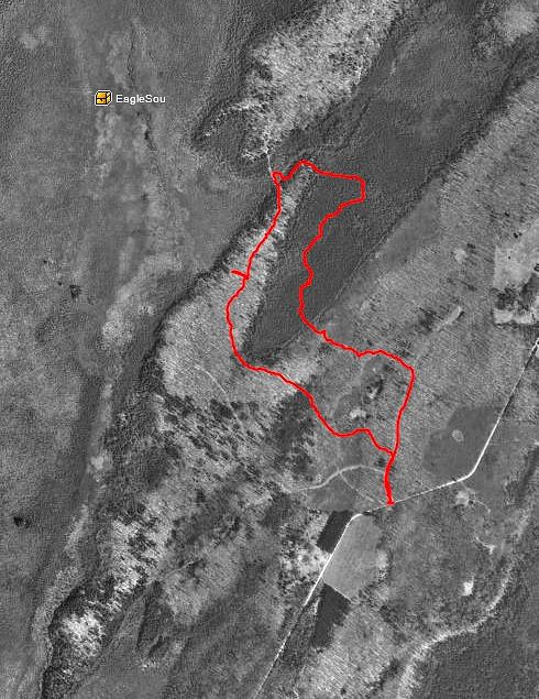
Here’s One Paddle’s track from their last attempt. Not sure which way was “in” and which was “out”.
 12/12/2009 at 11:55 pm #1918170
Sounds interesting and fun. Unfortunately we do not have snowshoes or the like to participate.
12/13/2009 at 12:24 am #1918171@Timberline Echoes wrote:
We parked 1 1/4 mile East of the cache, at a service gate road. That road only went in about 1/4 mile and when the road veered north we began to bushwhack through the hardwoods and then 1/2 mile of swamp.
If we are around when you guys do this we could meet you all for a celebratory dinner somewhere after… it is a great one.
TEHappen to remember what service gate? :>
12/13/2009 at 12:29 am #1918172The northern track is the “in”. You can see that when we entered the thick swamp we could have- and should have- come out shortly to some hardwoods before entering the more marsh-like swamp. But I turned us right, then you can see a little better angle that turns right again, and repeat. I do think the electronic compass needed to be calibrated also and we were traveling at a slow enough rate that my GPS would have switched over.
Finally I gave up the trekking poles and just followed the arrow- but by that time we’d spent better than an hour at .8 mph going through that thicket and we were wet and it was cold. We were looking at more thicket and decided to turn southwest and follow the hardwood ridge looking for a better entry to the next swamp. You can see a projected path where we did find a good entry. But, we were so tired and wet, and I had no idea if we’d be able to avoid the swamp on our way back to the car or how long it would take us that I decided to call it and work our way back. As it turned out we found a MUCH better route out and it wasn’t anything like the in.
So, we will be able to avoid the thicket by following the track out and then following the higher ridge through the swamp to the cache. It will still be challenging but not the killer hike of last year.
Sounds interesting and fun. Unfortunately we do not have snowshoes or the like to participate.
It has been my experience that this kind of problem can be solved by Christmas and a credit card. 😉
Otherwise, we may have some snowshoes we could lend out too.
12/13/2009 at 12:31 am #1918173Happen to remember what service gate? :>
The red track begins at the service gate mentioned. That’s where we parked.
12/13/2009 at 4:01 am #1918174It looks like about half way up your red track from the gate to the Y in it is a pre-made trail that goes SW then curves back NW and ends in the middle of..trees? Swamp? It might be longer but a pre-built trail for some of the way may save some leg power.
12/13/2009 at 4:50 am #1918175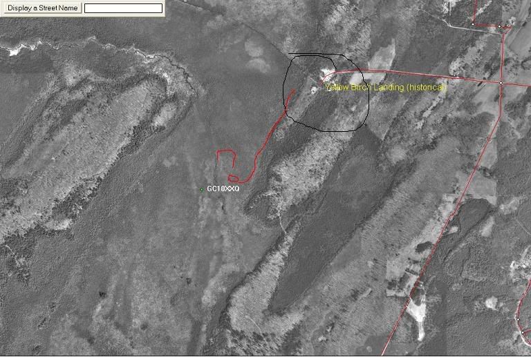
OK I think I have the right spot now.
Is there any way to go in from the north at Yello Birch Landing?
I drew that red line. Looks like a trail of some sort that heads south.
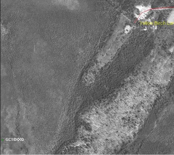
Or from that trail to the west?12/13/2009 at 1:38 pm #1918176Yellow Birch Landing (Historical)- Now that’s the kind of thing I find interesting! Who used that spot as a landing and when? Will have to see if there is any information on this…
From reading the cache page I believe that that route is how this cache was hidden. It would surely be shorter and easier and from reading logs it seems that some folks are still taking that route. However I think that, upon closer inspection, there isn’t really public access from that point? But I don’t know, I just know I drove down the road and it looked like a bunch of private cottages and such. Others have come to the same conclusion and have accessed the cache from the longer Atkins road route. I have no plat book to work from. Timberline Echoes is from the area and they chose to access the cache from Atkins road- so after a quick look down Yellow Birch that’s where we made our attempt.
The road from the west doesn’t look like much of a road- probably an old logging road. I’m pretty sure it won’t be plowed- may be a snowmobile trail? In any case I think that as a winter access we can forget about that route.
Rsplash-
Yes, I agree taking that Y isn’t a bad idea. There is a minor swampy area that was a little difficult to get through. Although our track does follow some kind of a decent trail through it. The place to avoid is that arrowhead shaped swamp pointing southwest. It was a very pretty and unique area but I’m not going back.
12/13/2009 at 1:46 pm #1918177Let’s throw out a couple of possible days. Honneybunnies say Sunday works best. So how about either Sunday, December 27th or Sunday January 3rd?
Either of those work for folks who are interested in an afternoon snowshoe?
I haven’t heard anything from Mathman but I know he wouldn’t miss this kind of thing…
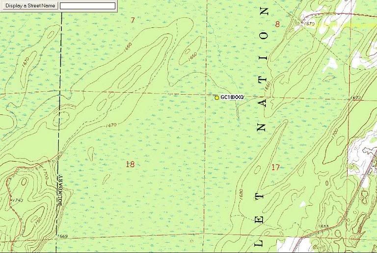
12/13/2009 at 3:15 pm #1918178I can definately make either of those two days. After plotting this in Streets and Trips. And comparing Atkins Rd. at 1.1 miles verses Yellow Birch Landing at .7miles. Also looks to be much more direct route. Either way it is going to be a good hike. With that being said I don’t think we should start out to late in the afternoon. But it’s OPS party.
12/13/2009 at 5:46 pm #1918179RSplash40 let me know about the goings-on.
I believe we drove down Yellow Birch Rd. I think we were able to drive to point A, but maybe it was only B.
Our goal was the point at which the USGS map showed the river beginning, but we never did find much sign of a channel in that general area – we didn’t look too hard though, we had to save our energy for the hike out.

(My seven-year-old niece just pointed out that the land form east of the cache looks like a bird. She thought a hawk, I’d say turkey,… maybe eagle?) 🙂
Have fun and good luck!
ps: my Time Warner webspace has been working in fits and starts the last few days, there may be times when the picture doen’t show.
12/13/2009 at 6:05 pm #1918180@One Paddle Short wrote:
.
Sounds interesting and fun. Unfortunately we do not have snowshoes or the like to participate.
It has been my experience that this kind of problem can be solved by Christmas and a credit card. 😉
Otherwise, we may have some snowshoes we could lend out too.
The credit card won’t support it this year. If we can get three pairs of shoes, we’ll join you. Either date works for us. We’ll update on our status.
12/14/2009 at 2:16 pm #1918181It sounds like a good time. Interested in having another tag along if the date works for me? Last years Trip to the Philippines was a disappointment due to the fact of the impending storm kept me home and didn’t rear its head until well after the fact.
12/14/2009 at 4:18 pm #1918182OPS, what did you find out about Yellow Birch Landing? I’ll I can find it that “something” used to be there.
12/14/2009 at 7:07 pm #1918183@astrod-team wrote:
@One Paddle Short wrote:
.
Sounds interesting and fun. Unfortunately we do not have snowshoes or the like to participate.
It has been my experience that this kind of problem can be solved by Christmas and a credit card. 😉
Otherwise, we may have some snowshoes we could lend out too.
The credit card won’t support it this year. If we can get three pairs of shoes, we’ll join you. Either date works for us. We’ll update on our status.
Astro – I think it cost me ~20 bucks to rent a pair last year from Schepard and Schaller in Wausau.
-
AuthorPosts
You must be logged in to reply to this topic.