› Forums › Geocaching in Wisconsin › General › Trail Mapping
- This topic has 4 replies, 4 voices, and was last updated 17 years, 3 months ago by
 Team Black-Cat.
-
AuthorPosts
-
10/14/2008 at 11:57 pm #1727213
Has anyone done any area mapping that includes adding GPS track (of existing trails) and overlay that on a scale topographic map or aerial photograph?
If so I was wondering about the software required and the proper order of combining the information.
I have a local school district that has a dandy school forest I would like to provide this data for as they don’t have a comprehensive map of the area.
Any help would be greatly appreciated.
Da Bloodhound
10/15/2008 at 12:44 am #1896936DB,
I have taken my tracks and uploaded them to Mapsource. Editited the many circles it took me to find the cache and left just the trail. Then saved it as a GPX file. I then drag the file into Google earth. The tracks show up. I can then edit waypoints in and name the track.
I hope this helps out a bit.
Hemi
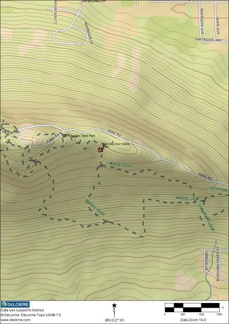
10/15/2008 at 6:23 am #1896937DB,
Delorme has some of the best mapping software available. I’ve added a few trails to existing maps which can be layered with topos, aerials or whatever. This is the trails at Rib Mountain over a topo map. Some of the trails that I haven’t been on were drawn in, but the result is the same. Done with Topo USA.
 10/15/2008 at 9:25 am #1896938
@Team Black-Cat wrote:
DB,
Delorme has some of the best mapping software available.This is why my next GPS is going to be the PN-40. The Topo 7.0 software is usually $99, but delorme incudes these with the PN-20 and the new PN-40 so you are really getting a great deal when buying a Delorme.
I’ve heard you can add your own trails to the maps with the delorme which is pretty awesome. I read a few Forum post about getting the Xmap software from delorme and you can then Import scanned images of trail maps, or even screen captures maps and trace them to add trails to your delorme maps.10/15/2008 at 8:25 pm #1896939Exactly, Hogrod. If you only want the topo maps with trails overlaid, then Topo USA will work fine. I think that Delorme is still including a $100 certificate to download pre-registered (aligned and scaled) maps. The have USGS topos, aerial and sattellite photos, and quite a few other formats. Any of the maps, including hand draw trails can be downloaded to the PN-20.
I upgraded to X-Map Pro for a good price. That included another $100 certificate. You can also scan or download any map and use the software to register it. That’s about the only added function, so Topo USA would probably as much as anyone would want.
As for the PN-20, I be polite and just say that I’m finding it “cumbersome” for geocaching. The only way to load caches is by using one of Delorme’s mapping programs or manually. It’s also kind of slow on map re-draws and moving from menu to menu. Reception is rock solid and accurate. The features of the PN-40 look identical to the 20, but it’s supposed to be quicker.
In short, I love the software. The PN-20… not so much. -
AuthorPosts
- You must be logged in to reply to this topic.