Forum Replies Created
-
AuthorPosts
-
I guess I have to be logged in to reply. Hello thread stealers.
March 2021 pathtag update. There are now 133 known WGA members past and present that have created at least one pathtag (plus some group tags). Shown here is one pathtag from each of them (some have created many pathtag designs). Pathtags are trackable personal coins/swag similar to travel bugs that people trade or put in caches, except that when you find one you get to log it and keep it! 🙂

Wow, a rare FTP for me. I would have gladly trade it for a Packers victory.
Crossing fingers here for the final test for a second annoying bug in the forums. First the thread count and certain paginations are now fixed and are not at crazy hi numbers. Second hopefully now the most recent post and links in emails bring you to the page of the post. Crossing toes now too!
Wow, THANK YOU CHRISTOPHER!
Just got done with the craphas relocation. About 6 to 7 inches here in Milwaukee County.
WOW! The WGA website loaded really fast! Something has changed. It’s the first time I think I’ve visited the thread stealers forum in a week or two, so maybe it’s been this way a while. getting in on page 1225 on almost 12/25.
Gee I should probably hope the weather in SE Wisconsin gets cold soon. It’s too nice out to stay indoors, so I’ve been golfing or trail hiking 4+ miles (with a cache or two along the way) almost every day for the past 10 days. My body needs a rest. And there’s chores to be done. Of course, if it turns cold that will only stop the golfing, not the hiking & geocaching…
I VOTED
For Chris Walker. Not saying when, or for what, but I did.
I’d like to see the picnic and campout dates switched as well, with future campouts in the late summer/fall and the picnic late spring/early summer. The reason is this:
The 3-day spring campout event is always cooler weather, sometimes with snow or frost still on the ground. It makes it tough to camp overnight for many folks that aren’t used to cold-weather tent camping. Traditionally the campouts have been during that time. I’ve only been to 7 or 8 WGA campouts, but I seem to recall almost every year there being frost and/or rain at night.
The weather is usually nice for the late summer/early fall 1-day picnic event, which has traditionally been during that time.
Why not have the better weather (fall) for a 3-day event so we can enjoy the fall colors for up to three days, and the more challenging weather (spring) for the 1-day event, where overnight camping isn’t practiced by most? (Of course, geocachers are allegedly hardy outdoors folks in any weather, right…?)
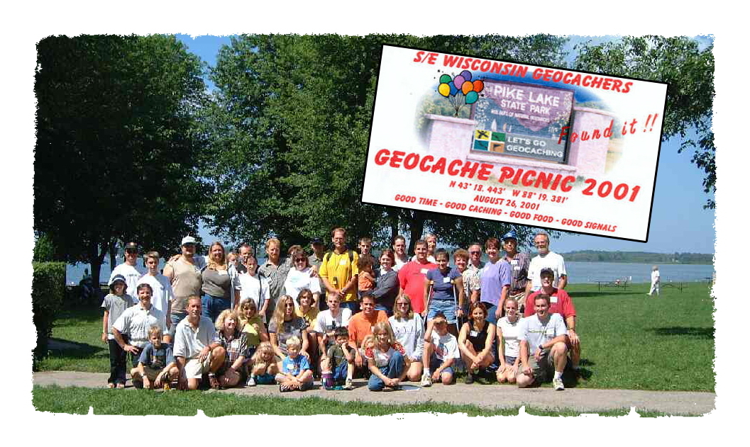
Historically speaking, the first picnic took place late summer (8/26/2001) but there weren’t any campouts back then. The following year and ever since, the WGA continued the tradition of a late summer/early fall picnic. But in 2002 the WGA added a spring campout to go along with their “fall” picnic. It’s been that way ever since, since that’s how it started. But weather-wise, it really seems to make sense to switch dates so that the campout would be scheduled for the fall (Aug or Sept) and the picnic scheduled for the spring (May or June).
There’s nothing like getting a Noonan 5-difficulty FTF in the afternoon! 🙂
The annual WGA campout is this weekend!

Happy Labor Day!
Just brainingstorming, ignore this post. Badges. Project-gc. Challenge caches. Where are they now. Adventure labs & virtuals. New attributes. Continuing education. Smartphone apps. GPSr receivers. Geo-HTML. Premium vs. basic. Waterproof containers. Log sheet downloads. Log sheet wear & tear. Lonely caches. Micros in the woods. DNFs. Playgrounds and train tracks. Pathtags vs geocoins. Aardvarks. BOD benefits. Creative letterboxes. Cache props. Cache maintenance. Field puzzles. Geochecker issues. Goals. Jasmer. gear. Waterproof footwear. Why GSAK. Planning a day trip. Related hobbies. Insect repellant. Permissions. Software. Finding damaged containers. Carrying extra log sheets.Frequency. Winter. SWAG. Geoart. Your one thing. Making favorite-worthy caches. Adding pictures to cache pages. Adding WGA logo. Facebook. Geocaching-related blogs. Geocaching-related online stores. Geocaching-related websites. How to. Getting acurate coords. Google maps, Google Earth, Bing maps. Coordinates conversion. Puzzle solving tools. Map sources & types. Editing your profile page. WGA membership map. WGA website. How not to hide a cache. Micros in the woods. Top ten. Wayback machine. Cachestats software. Cacherstats.com. Pocket Queries. Maps. Writing decent logs. Field notes/drafts. Photo of the month. Regional Geocaching Policies link. TOTT. Events. Labels. Profile add-ons. Cache rescue. Ice Age Natural Scenic Trail. State Natural Areas. State trails. State forests. State Recreation Areas. Region information. Trackables. Hey – I said ignore this post!
My hiking buddy has a state parks pass. We had a trip planned to Governor Thompson State Park in July that got bumped to today. Unfortunately, I had no reception at the park. I had printed a trail map and had all the coordinates loaded, but I couldn’t see what caches were on which trails.
Debby you can load free maps on a GPSr that will show the trails of all of the state parks, and on smartphones you can load offline maps that will show the trails as well. On a smartphone you can load the caches “offline” on to the phone’s drive so you don’t need reception, and can put the phone in “airplane mode” so that the wifi and bluetooth are off, that way you don’t eat up the battery much, but can still navigate to the caches, with trails, because of a smartphone’s built-in GPS chip. A bit complicated to set up the first time, but after that it’s smooth sailing.
We’ve done our part….hidden 26 since the whole shutdown stuff started in mid-March. Plus one Adventure Lab.
Wow! New series?
-
AuthorPosts