Forum Replies Created
-
AuthorPosts
-
Feverish Portage County Summer Evening https://www.youtube.com/watch?v=ktFqfc25Iqg
in reply to T&B influenza dream…………….after 10 days of jungle fever from this end.
Think this is correct, but not 100% certain; does match up with T&B’s response for Lacrosse Co. above.
WASHBURN COUNTY
https://coord.info/GCMZQ1
Ducks on the Pond
Hidden : 03/03/2005LACROSSE
https://coord.info/GC9594
Oktoberfest 2002
Hidden : 09/28/2002CHIPPEWA
https://coord.info/GCJ3MH
Old Abe’s Wildflower Trail
Hidden : 04/02/2004nothing to see here…
move along. 😉
In Green Bay: http://coord.info/GC7BA21
Looking in the log of that cache, looks like Crow-T-Robot will be placing one somewhere someday.
On the right track. Upload url to a site like this: http://imagecolorpicker.com/en. Note that the image color on the right side varies slightly, so you may need to pull a few different numbers and try them before you get the right one.
Have Fun
… on our way to Costco to top off the rental car’s gas tank…
Been there, done that!
 (Mr. S’s sister used to work at that Costco… She’s retired now.)
 It’s because of that Costco we bought a membership. Perhaps Mr. S’s sister sold it to us. Good deal to this day….they finally expanded west of the Mississippi, and our GPS now says we live within 2 miles of one. Holy Cow! Just about time for the semi-weekly free lunch buffet (all the free samples easily add up to 1000 calories!
)And Happy Birthday Labrat! Sounds like the big Five-O, eh?
FTF ALERT FOR BARTROD! This cache just published an hour ago within 5 miles of the airport. (might be the same CO that did the puzzle you mentioned grabbing?)
bartrod might still have time for a run to the top of Mauna Kea to help ease his transition back to WI………….. :-p

Smile for the Camera! The BIG Camera!
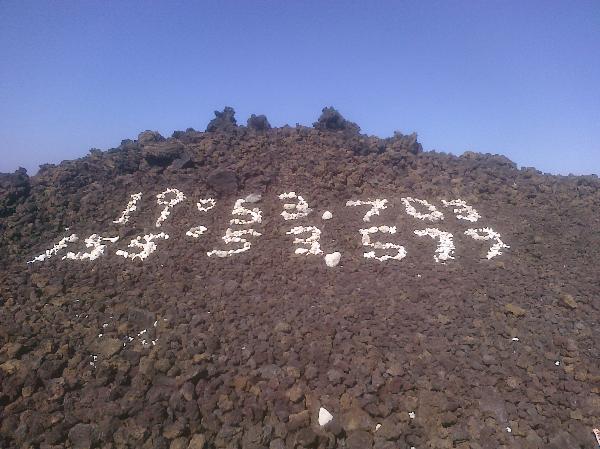
…am curious where HP2’s coordinates would take us!??
The N/W coordinates were meant to identify GZ of the Grafiti Galore Virtual, hope we got it right. Without the W or a ‘-‘ before the second number, it’s likely on an atoll or a cargo ship further west in the Pacific? 😉
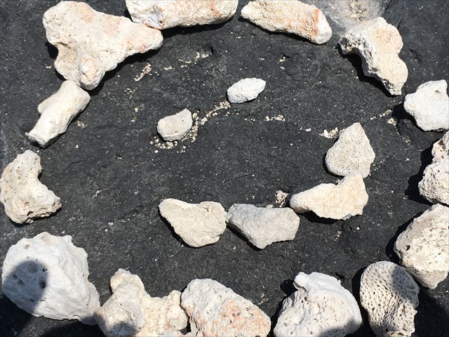
The white rocks are actually bleached coral gathered from beaches. This coral was popularly used to create graffiti, LOTS of graffiti, along the western-most highway that passes through a very dry, dark ‘lava desert’ region north of Kailua-Kona. But in the Spring of 2012, a grassroots-based clean-up of this ‘litter’ was undertaken and relatively little graffiti now remains near the roadway. It is illegal to remove coral from the beaches, so it is likely the material bartrod used was already in the area of the Virtual Cache. These days, the graffiti created for the Virtual is generally small and/or out of sight from the highway. The photo of the Coordinate Graffiti we created was relatively large, about 20′ long, and done in 2009. There was so much graffiti in the area at that time, it was very hard to actually ‘pick it out of the crowd’.
– Aloha!
Surely you visited Quinn’s when you were nearby, bartrod… we did.

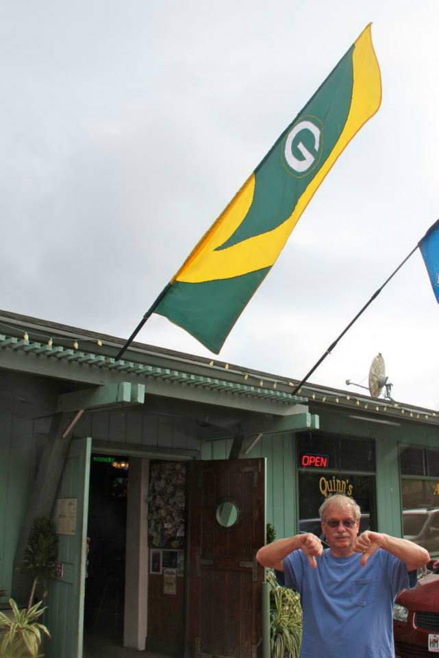
Perfect Picture! We like to sit on the curb in front of Quinn’s to watch the Christmas Parade wit da brudda-in-law before going inside for a nice meal in the wonderful Green & Gold Hawai’ian Packers atmosphere; Sandlanders musta forgot to mention that part……… 😉
Holy cow! Looked at the Satellite View where the above image was taken – and look what we spied!!!!!!
I had an image of island graffiti…no luck posting from my cell…trust me. There’s a smiley out there

This graffiti earned us a smiley
Trying to recall what the Mission of the WGA-SPS is/was. Cannot easily find it on this site, and the discussions covering its inception and development are no longer here either.
Think part (A) of it’s intent was to serve as a Gateway to introduce (recruit?) and encourage new geocachers to Geocaching and the WGA?
And perhaps another part (B) was to serve as a cornerstone of a strong and active relationship among Geocaching, the WGA, and the WI State Parks?
If there is truth to the above,
Then:
A + B = Mission Accomplished?
or
A + B = An ongoing Mission that was developed to be an integral part of the WGA itself?
Just wondering, as there sure seemed to be a lot of effort and energy put into the Series’ development and implementation. If the WGA decides it wants out, whether by original intent or new directions, perhaps the Series can morph into a ‘Geotour-ish’ grouping of caches that live on to showcase the State Parks, the WGA and their close relationship?
HP2, we hiked 100 miles of the IAT this year from April to October, from Skunk and Foster Lakes to the Wisconsin River bridge on Highway 82 . . . If you haven’t done the Deerfield segment in northern Waushara County, we really enjoyed that. It’s private land, and I think it’s closed during gun deer season, but it’s a nice variety of terrain and landscape to wander through.
Congrats on taking a big chunk out of the ‘Thousand Miler’ challenge, whether you’re after that or not; very impressive! There must be a single word for what you experience on the IAT that keep you coming back for more, but likely not in modern English.
And thank you for the tip of visiting the Deerfield segment! Looks like we once visited just a bit of it to visit a Lil Otter cache, think it was lonely? Will make it a point to return when the ticks are sleeping. 😉
p.s. Always thought there would be a Juneau/Adams IAT Chapter; know of a any passionate volunteers familiar with that area? nudge, nudge
-
AuthorPosts
